Category: Planning (Page 1 of 6)

Pavement Parking – how to avoid a ticket

A couple of weeks ago, we were contacted by residents of Vennard Gardens following a complaint from a person with a pram who was unable to use the pavement due to cars being parked on it at the Pollokshaws end of the street. As a result of the complaint, parking tickets were issued to vehicles parked on the pavement along the entire length of the street, if they left under 1.5m of pavement width. Cars parked on the pavement had previously been ticketed in Marywood Square after a complaint that one vehicle blocked someone’s front gate. This has caused a lot of confusion and anger amongst residents.

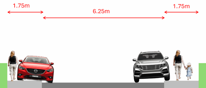
The Society asked the Council about this. In short, although Strathbungo is still ‘in consideration’ regarding pavement parking, until there is a full exemption agreed and signage to that effect per street, cars parked on the pavement will not be exempt from enforcement. The criteria for enforcement are a) The council receive a specific complaint and b) The vehicle(s) does not allow a pedestrian/wheelchair user to pass (defined as 1.5m, the minimum recommended width of a pavement).

So, please be mindful of where and how you park in the area. The Garden’s pavements are wider than the Squares (typically 1.75m) so please be sure to park with space to allow pedestians/wheelchair users to pass on the pavement. In the Squares the pavements are much narrower. Here the guidance remains more ambiguous, but be mindful that if you are parked close to a garden gate into a property, make sure there is plenty of space for residents to enter/exit their front gardens easily and safely.

For full information about pavement parking please go to GCC Pavement Parking Prohibitions

The council have sent us an abridged version as follows:

Assessment

Our assessment progress can be viewed on our interactive map, where roads are now coloured Red, Yellow or Blue.

Blue: Roads within future proposed parking zone boundaries
Status: Not being considered for exemption at this time. Any consideration for an exemption will be considered as part of the parking zone proposals.
Enforcement: Pavement parking enforcement will be carried out if: 1. We receive a specific complaint and 2. The vehicle(s) does not allow a pedestrian/wheelchair user to pass

Enforcement

The enforcement of pavement parking, double parking and parking at dropped kerb crossing points is underway. The enforcement team are now dealing with any issues as part of their reactive complaints process. The public can highlight issues with pavement parking, double parking and parking at dropped kerb crossing points through “reporting a parking problem”.

We reserve the right to enforce in any street, including those shown in yellow* on the interactive map, should any clear safety issues be brought to our attention, to comply with our duty to ensure public safety. E.g. vehicle(s) parking on pavements and forcing pedestrians on to the road to bypass the vehicle(s).

* This also includes streets shown in blue

Exemptions

Until such time an exemption order is implemented, it must be noted that no roads are currently exempt from pavement parking. However, enforcement will only be undertaken on these roads if vehicles are fully obstructing a pavement which would force pedestrians/wheelchair users on to the road to bypass parked vehicles, as outlined above.

Any further updates to Pavement Parking Prohibitions will be provided on the webpage and specific information on the assessment for streets in Strathbungo will be included in updates on the proposed RPZ for the area.

I trust this information will be useful in informing the residents of your community.

For clarity the map (previously purple and green) now has three colours:

Red: Pavement parking ban now being enforced (most roads)
Blue: Within a proposed future parking scheme (includes all roads in the Strathbungo Society area)
Yellow: Exemption being taken forward (rare, nearest are in Mount Florida)

Any further updates to Pavement Parking Prohibitions will be provided on the webpage and specific information on the assessment for streets in Strathbungo will be included in updates on the proposed RPZ for the area.
What is a Home Zone? And why do we need one?

Like many, I have significant concerns over the council’s proposals for Strathbungo. But rather than rant, I would like to present a radical alternative approach that could be better for both pedestrians and motorists. Let me explain.

Firstly, note this is a personal opinion, not an official policy of The Strathbungo Society. Secondly, I am making a few basic assumptions:

  • I am not discussing the bin hub issue here
  • The residents’ parking permit scheme is probably inevitable, though it might need tweaks
  • The pavement parking ban is inevitable, because it is the law

If you have gone through the council consultation’s questionnaire already, you will have seen questions about a “Home Zone”. This is at our instigation, so I had better explain what a Home Zone is, and why I think it is a better option.

Continue reading

Crossmyloof Resource Centre Consultation

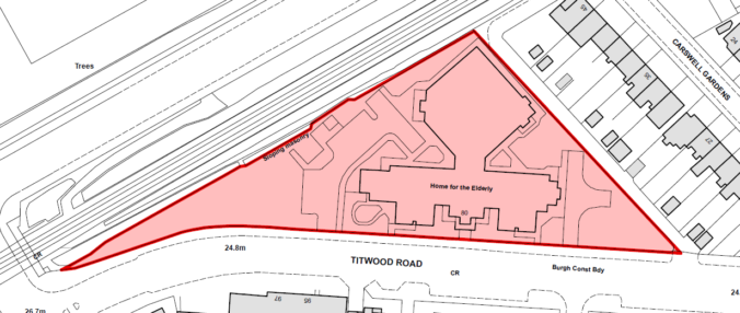
The second public consultation event in relation to the proposed development at the Former Crossmyloof Care Home, 80 Titwood Road, Glasgow, G41 2DJ, will now take place on Thursday 7th August 2025 between 2pm – 7pm at Queen’s Park Baptist Church (The Point), Thornwood Suite, 180 Queen’s Drive, Glasgow, G42 8QD.

This is prior to submission of the formal planning application.

Members of the project team will be available to answer any questions on the day of the event, similarly a dedicated email has been set up for any online enquiries – titwoodroad@iceniprojects.com.

Big changes are coming!

Big changes are coming to Strathbungo! Have your say!

We have got wind of an upcoming council proposal, due in late August, that will likely propose major changes to the roads, and the bins, in the area. The aim is to tackle three problems:

1. How to introduce the pavement parking ban (our exemption is only temporary)
2. How to introduce a residents’ parking permit scheme
3. How to improve bin collection, possibly by using on-road communal collection points

The Society hopes to influence any plans for the better when they come, but we realise opinions vary.

Note: The survey has now closed. Results will appear on bungoblog.com in due course. Thanks for all the responses.

The future of Crossmyloof Resource Centre

***UPDATE***
The second consultation on 5th February has been postponed to allow Westpoint to develop their plans further with the council, taking on board feedback received. A new date will be announced in the future.
***UPDATE***

Councillor Molyneux has tipped us off about some upcoming pre-planning public consultation by the developer Westpoint Homes. So if you want to see what Westpoint are planning, and wish to comment, get yourself along to one of the events.

In line with The Town and Country Planning (Pre-Application Consultation) (Scotland) Amendment Regulations 2021, two statutory consultations will take place in relation to this project, both at Thornwood Hall, in The Point, the Queens Park Baptist Church community centre at 180 Queens Drive.

  • Wednesday 4th December, 2-7pm
  • Wednesday 5th February, 2-7pm

Feedback forms will be available at the first in-person event which can be completed and submitted to the project team until 25th December 2024.

The above consultation events will be advertised in the Glasgow Times a minimum of 7 days prior to each event taking place. Notified parties will receive correspondence confirming these details in advance.

Further information on the proposals is available from Iceni Projects via the below:

0141 473 7338
201 West George Street, Glasgow, G2 2LW
titwoodroad@iceniprojects.com

Update

The display boards from the first consultation are available to download (pdf).

Following feedback the plans will be developed further prior to the next meeting in February.

Planning application for Nithsdale Street – steel container for open air cafe & takeaway

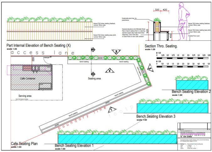
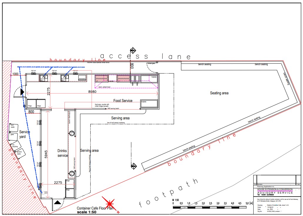
A planning application for the vacant ground at 47 Nithsdale Street has been submitted, and can be viewed at Glasgow City Council’s Planning Portal, using reference 23/01662/FUL. The application is titled “Use of land for siting of steel containers for use as cafe and hot food takeaway (Sui generis), includes installation of flue extract, with external seating area and erection of fence.”

Whatever your views, you can respond before the deadline of 25 September. You can find some useful guidance on responding to planning applications at Planning Law Blog.

It is worth noting that this vacant site sits within the conservation area, although, oddly, the adjacent buildings (World Foods, etc) do not (there is a map on the BungoBlog).

Full site plan including the two steel containers, and open air bench seating

And here’s the site as seen on Google Maps. It’s been tidied up and the gable end wall repaired since this view however.
View from google maps of site on Nithsdale Street

Arnold Clarke site planning application

The planning application for the second of the Arnold Clarke sites (134 Nithsdale Drive) has been submitted, and can be viewed at Glasgow City Council’s Planning Portal, using reference 23/01956/FUL.

Whatever your views, you can respond before the deadline of 22 September. At 104 flats, this is possibly the largest development in Strathbungo area since the 19th century, so please consider making your views (positive or negative) heard. You can find some useful guidance on responding to planning applications at Planning Law Blog.

It is worth noting that the site is not within the Conservation Area but is directly adjacent to it. The site is surrounded by Listed Buildings at Moray Place, Salisbury Crescent and Darnley Street (there is a map on the BungoBlog).

Editor’s note:

Thanks to Toby for submitting this.

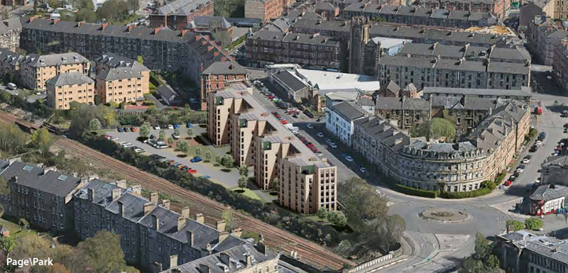
Here’s an aerial view
Aerial view of Page park proposal at Nithsdale Drive

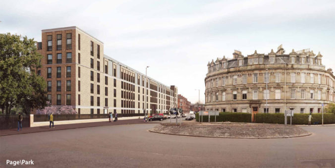
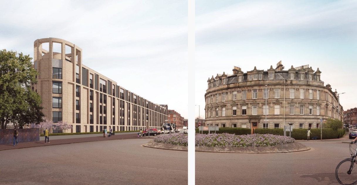
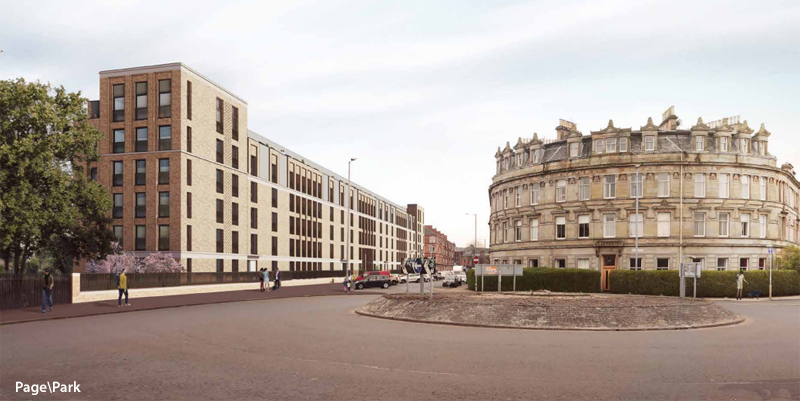
The architects state “Our design thinking seeks to ‘fill the gap’ complementing the scale and aspirations of surrounding buildings, with particular reference to the work of Alexander ‘Greek’ Thomson, whose Category ‘A’ listed terrace, Moray Place faces onto the site.”

Note here’s what the plan looked like as originally proposed in March. While the block is similar, note how the detailing and the curved end features have been dropped and an extra flat stuck on each end instead.

View from Page Parks original proposal

Original proposal

Proposal for Nithsdale Drive as seen from the roundabout

Current proposal

nithsdale-drive-arnold-clark 2 nithsdale-drive-arnold-clark 1 nithsdale-drive-arnold-clark old

Back Lane Repairs Update

We have previously reported on plans to undertake some repairs to the back lanes.

It’s been a bit quiet since, mainly because the Council then decided to require us to make a planning application. We have just been informed we have permission to go ahead, and we are looking at a possible start in late April, or failing that in July, depending on the availability of our contractor, Richard Birch Gardens.

The planning application applies to both Vennard/Marywood cross lanes where they meet Vennard Gardens. It can be accessed on the Glasgow Planning Portal, ref 23/00175/FUL, or this direct link might work.

The Marywood Square back lane repairs are just that, and simpler in scope, so we have not pursued a planning application for this work. It may also ultimately be outside our fixed budget, but we will endeavour to achieve what we can.

Meanwhile we were originally told this could be a pilot for further repairs, but have since been informed that we can only apply for funding once. So unless there is a change of policy, the project stops once this work is done.

Nithsdale Road Bridge Reinstatement

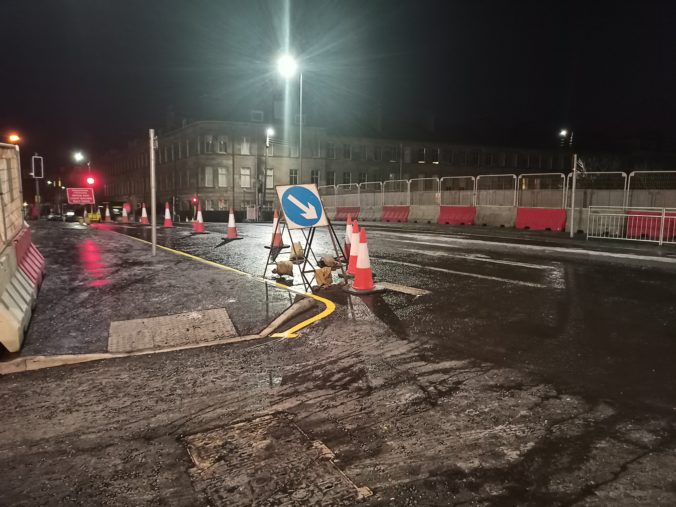
The Society has been attempting to engage with Glasgow City Council about the road design on the new bridge since 2019, with the aim to encourage active travel such as walking and cycling, but it wasn’t until November 2022 that we got any response. With the aid of Cllr Jon Molyneux, GoBike and others, agreement was reached regarding improvements on the bridge and junction, including a segregated bike lane.

So we were massively disappointed when the bridge re-opened with the exact same road design as on its predecessor, as was our Councillor. It appears council officers “dropped the ball”.

The Society has written to the council to express our disappointment, and the letter is reproduced below (appendices removed for brevity):

Derek Dunsire,
Group Manager Liveable Neighbourhoods,
Glasgow City Council
Derek.Dunsire@glasgow.gov.uk

26/1/23

Dear Mr Dunsire,

The Strathbungo Society has been trying to engage with Network Rail and Glasgow City Council on future plans for the Nithsdale Rd bridge ever since the plans for electrification of the line were given the go-ahead. For example, after the very helpful presentation given by Henry Dempsey to the Pollokshields Area Partnership about plans for the bridges in the ward and the respective responsibilities of the Council and Network Rail, we tried to engage further (correspondence appended). We had very little success with either NR or GCC but were therefore extremely hopeful when at Cllr Molyneux’s instigation you held a site meeting on the 8th November 2022 which was attended by Cllr Molyneux, a number of GCC staff, a number of the Strathbungo Society Committee and a representative from the Glasgow Cycling Campaign. We were told then that GCC staff had been working on the design of the road across the bridge, to ensure it was future proofed and that it would include a two-way segregated bicycle lane. Your staff also undertook to look at other issues, for example to address water run-off from the extensive area of hardstanding, perhaps by creating a green soakaway / SUD.

It was with dismay therefore that the Strathbungo Society witnessed the contractors returning the bridge to how it was with the same narrow “murder strip” (Go Bike) for cyclists on the north side of the bridge as previously, which is unlikely to meet modern design standards . We understand from Cllr Molyneux that the reason for this is partly that a TRO was required and this was not done in time. While we understand the pressures you and your staff are under and you may not have direct responsibility for TROs, we would appreciate a fuller explanation of what has gone wrong. It seems to us to be crazy that when the Council is so short of resources that we are now in a position where the road over the bridge will require to be dug up again to install the bike lanes. What a waste! Moreover, now the road is open again we suspect there may be more objections to any proposed new traffic layout than there would have been if this had been progressed while the bridge was closed.

We note that on the internet – https://urban-future.org/speaker/derek-dunsire/– you describe yourself as “making cities more sustainable through community-led activities at a local level, involving residents, academia, businesses, city authorities, and other stakeholder organisations … focused on delivering real outcomes and not just project outputs … by working collectively”. Unfortunately, there has been a total absence of any collective working on the Nithsdale Rd Bridge – between the community, Network Rail and Glasgow City Council and elected Councillors. In fact, it seems to have been a “closed shop” of GCC and NR. The Strathbungo Society has never been provided with plans, either by Network Rail or by the Council, of how the finished road bridge would look. Had we been given sight of the plans, we might have also been able to ensure that appropriate action and amendments were made, saving time and money for all concerned. The issues continue we now have serious concerns about the nature and the standard of the stone facing to the concrete parapets which don’t appear suitable for a conservation area. The contractors, BAM, have now been out to look at the work after comments on social media and we would be grateful if you would now ask a planner with conservation expertise to look at the work.

At the onsite meeting we asked for a contact to liaise with the Council on matters to deal with the bridge. Unfortunately, you declined to provide a named contact and instead suggested we use the generic Liveable Neighbourhoods email. The consequences of that failure to appoint a lead seems to us linked to the failure of GCC to provide us with the courtesy of a message explaining what had gone wrong.

The wider issue here is that in good faith we have started to engage with the Liveable Neighbourhoods Project Team at Atkins. It is clear from that that there is very little corporate memory within Glasgow City Council and we have had to provide them with copies of work we did on the Nithsdale Rd area as part of the Pollokshields Charrette. While we understand some of the challenges you and your staff are facing, and don’t mind providing Atkins with information where we can, with GCC now apparently so short of resources that it cannot even deliver a simple project for a bridge we have serious concerns about how any Liveable Neighbourhood Plan for our area can possibly be delivered. That raises the question of whether GCC, instead of outsourcing plans to contractors, might not be better employing staff and increasing its capacity to DO things.

To take things forward in a constructive and collective manner, we propose a meeting to be convened by elected Councillors and to include the Strathbungo Society, the two Community Councils, Go Bike and GCC officials (LNT, NRS / Roads) to review what went wrong – and more importantly to discuss and shape proposals for Strathbungo portion of approved design work for the active travel route between Pollokshaws Rd and Dumbreck Road – which crucially include the road bridge and environs.

The Strathbungo Society is very supportive of the Council’s active travel plans and would like to be in a position to help make these happen by explaining their benefit to local residents. To do this effectively will require collective discussion on design and action on delivery and implementation. In the respect the Society would also like to see early movement in 2023 to establish a new active travel route between the south end of Moray Place to link it Titwood Road.

Yours Sincerely,

Paola Rezzilli
(Chair Strathbungo Society)

cc Cllr Jon Molyneux, Cllr Zen Ghani, Bailie Norman MacLeod, Bailie Hanif Raja, Shawlands Community Council, Pollokshields Development Trust, Go Bike

We have also been in touch with the contractor responsible for the stone facing being installed on the bridge, with concerns about the quality of the initial work, and they have promised to review this.

If we get a reply, we will let you know.

The Arnold Clark development – Planning Application

Further to previous posts on this subject (in February and April), the planning application for this development is now live and you can read it on the Glasgow Council website: Glasgow City Council Planning Department.

Search using the application reference: 22/01468/FUL

The last date for comments is Tue 19 July (see “Important Dates” tab for the application).

Continue reading

« Older posts