
The footbridge
The footbridge is being replaced in the coming months, and should be in place by mid June and open in July.
You will have seen the single lane closure to establish a base on Darnley Road. Further closures are coming:
28 April-2 May
12 May-16 May
2 June-5 June
Complete closure of Darnley Road between Sainsbury’s and Kildrostan Street over three long weekends
5 June-13 June
Closure of Moray Place
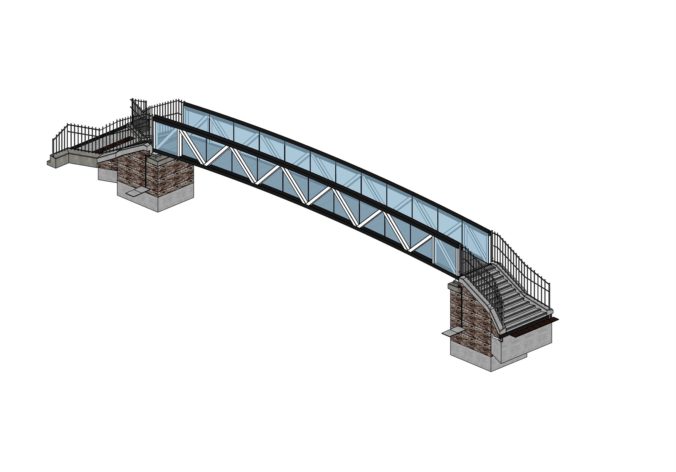
This is the design of the replacement:
Network Rail’s latest design proposal. Apologies for the low resolution, but that’s what they supplied.
We have had some further detail (only after pressure…) as follows:
I understand the architectural drawing on the planning portal is the most update-to date-drawing we have. One of the things I was checking was, to see if we have a larger version of the drawing than the one featured on the portal that shows just the bridge. As we don’t, we have lifted the bridge from the existing drawing, as per the attached, and increase the scale of this so it is a cleaner version that hopefully allows you to see the bridge in more detail.
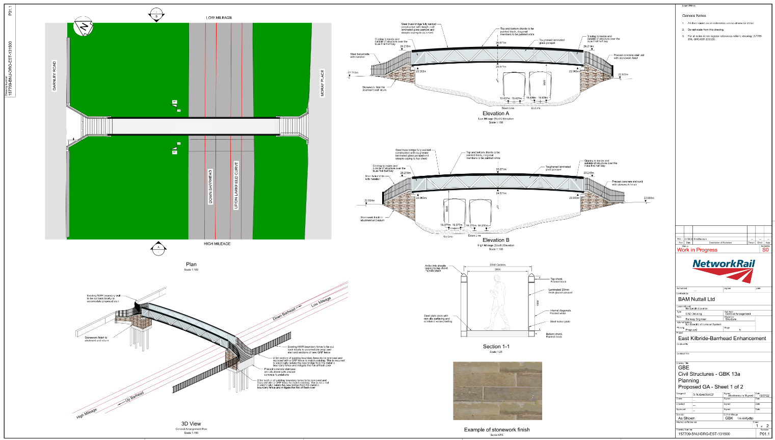
The impressions showed the parapets at a significant height (2.3 metres), which has since been modified to the standard parapet height for electrified lines (1.8 metres). The reason for this is, that it was felt reducing the height of the parapets was in keeping with the more modest structure of the former footbridge.
Incorporating elements that are sympathetic to the previous footbridge extends to the colour of the new structure, which will be black and white as opposed to the grey featured in the artist’s impressions. Also, the balustrades will be made of open steelwork and will match the railings already in place at Moray Place.
The entrance to either end of the bridge has been fanned out to address feedback from some residents, who wanted a more open approach to improve visibility for users. There will be 10 to 11 steps that make up the precast, concrete stairs at each entrance to the bridge, and the lower part of these will be finished in stone cladding.
In terms of piling at Moray Place, when we previously carried out work to install the foundations to provide the support for the overhead line equipment, we used a method know as auger piling. This was instead of driving or hammering the piles to their required depth to mitigate the risk of vibrations. Installation of the foundations for the new footbridge will follow a similar methodology as the auger piling.
The area where we are currently working to install the bridge is to allow safe access to the worksite from now until the work completes in the summer. Prior to our work starting overall on the project, we carried out a Baseline Biodiversity Assessment. This looks at the biodiversity value in its initial form before we do anything. We then look at what the biodiversity value is following completion of vegetation management along the route, as this allows us to know what needs to be replaced to ensure no biodiversity is lost and will help inform any potential replanting.
Once the Barrhead electrification project completes, our intention would be to replant in the same areas or close by to where any loss occurred. However, this is not always possible due to land availability or the operational constraints of the railway from a safety perspective. Under those circumstances, we would look for areas out with the geographical footprint of the railway boundary and would engage with communities for their input as to where replanting could instead take place to make sure the biodiversity value is maintained.
We will have a better understanding as to where we can replant once the overall electrification project nears completion and we would be happy to update the wider community nearer that time to advise on our plans.
There remains some concern that planting “close by to where any loss occurred” could be anywhere in the neighbourhood, and the railside could be left barren. Meanwhile here’s the higher resolution image they provided:
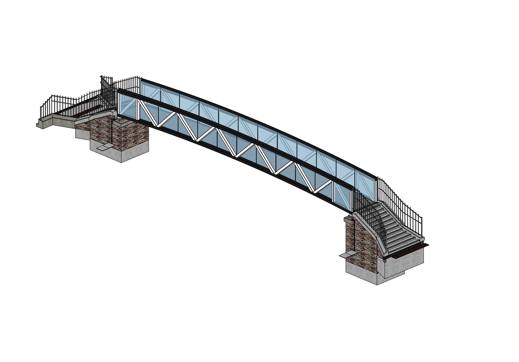
Footbridge detail. Source: Network Rail
The road bridge
We previously complained to councillors about the failure to include the promised provision for improved active travel on the road bridge when the surface was relaid, and other related issues. Cllr Ghani obtained this reply on our behalf:
Dear Councillor Ghani
We apologise for the delay in replying to your enquiry.
With regards to the enquiry from Strathbungo Society – following the site visit on the 8th November 2022, discussions within the Council Services identified that the availability of funding and council resources to support design did not fit with the remaining project timelines of Network Rail, and that the introduction of a segregated cycle lane on the bridge with no funding available to provide appropriate tie ins at each end presented a Health and Safety Risk that could not be designed out within the constraints of the new bridge deck. Funding for the design of the Inner South City Network to RIBA Stage 2 (Concept Design) which includes the Nithsdale Road bridge and surrounding environs, has now been secured from the Sustrans Places for Everyone (PfE) programme. This was approved at the City Administration Committee on 12th January.
The development of the Inner South City Network will provide an updated layout to the bridge deck, as Network Rail have replaced like for like. The section from Victoria Road to St Andrews Drive has been prioritised with the work being undertaken by the internal consultancy team Technical Services, and this work commenced at the beginning of March 2023. Whilst the bridge deck will be able to be accommodated under future works, please note that the bridge structure, including parapets, is in the remit of Network Rail. However, the concerns raised on the standard of the stone facing used have been passed over to colleagues in NRS Planning. As requested and confirmed at the site visit, the design team will collaborate with colleagues from Roads Maintenance and will seek to address the water run-off issue at Moray Place/Nithsdale Road, and will investigate all options including the creation of a green soakaway/SUDS scheme. Work on the design of the remainder of the Inner South City Network will be subject to a procurement exercise.
The Nithsdale Road bridge is a Network Rail project where they are a statutory undertaker. Although conversations were held on the matter in question and collective working was sought, unfortunately, at this time the opportunity went unrealised. This was due to a combination of allocating limited internal resources, alignment with an external Network Rail project and the challenge of delivering on the requirements of the TRO process within a short timeframe. Regretfully we were not able to ensure that the bridge deck was future proofed with the implementation of a protected cycle lane prior to reopening. Additionally the time available did not allow for meaningful community engagement. As part of the design process now being taken forward, stakeholder and community engagement will take place and we would welcome The Strathbungo Society input to this activity.
For all work on the Liveable Neighbourhoods programme across the city, the generic liveableneighbourhoods@glasgow.gov.uk contact email address is used and is monitored by the team. As part of the LN contract that Atkins are undertaking, there is a requirement to capture previous consultation data. A data pack that included the Charrette report was provided to Atkins. Due to their previous work on the “Make Your Mark” Charrette, Collective Architecture have been procured separately to provide a specific engagement for Albert Drive. Both teams are working in collaboration and are sharing all past and current information.
The LN approach allows for the generation of a long list of interventions for each study area. This can be utilised for funding opportunities as and when they arise, and where appropriate, be considered for delivery through existing GCC Service work programmes. The potential of an active travel route between the south end of Moray Place through to Titwood Road could be delivered through a filtered permeability intervention. This proposed activity will be noted and passed onto the Atkins team for inclusion in the wider dialogue. Such a proposal would be complemented by the introduction of the Glasgow-wide 20mph speed limit, which was presented to the Environment and Liveable Neighbourhood City Policy Committee on 31st January. Further engagement on the wider Inner South City Network will be undertaken when this activity is progressed later this year. This will allow the opportunity for The Strathbungo Society and associated stakeholders to input to the design for the local cycle network and in particular the connections between Pollokshaws Road and Dumbreck Road.
We trust this is of assistance
Intersting times, if any of it comes to fruition.

It would also be interesting to understand why we are all currently suffering BAM working every night from 10pm to 5am and running materials from their compound on Nithsdale Drive, constantly throughout the night, when this late working has not been notified by NR. It seems like BAM have become a law unto themselves with regards to operating within a residential area.